This is an old revision of the document!
Table of Contents
Moving Map
Real-time moving map shows current aircraft position, taxiways, gates, navaids, airways optionally on street or height map.
General Control
Keep the left mouse button pressed to scroll around on the map. Of course, also the corresponding touch gesture is supported.
You can use your mouse wheel to zoom in and out. Again also the two finger multi-touch zoom gesture is supported.
If you keep the CTRL key pressed and then select an area, you can zoom to exactly this area.
Additional an important control action is the right click or long touch for touch screens: You can use that to trigger several actions on many elements on the map (see also Pop-Up Menu).
Control Elements
In the following all control elements will be explained individually.
General
The buttons on the left side of the map toggle the display of various map layer whereas the buttons on the right side can be used to perform different actions.

If a button is displayed in white this layer or action is currently inactive.

A orange color shows a partly active layer or action. This mean for example that the structure of a layer (like a runway) is displayed, but not a corresponding text (like the runway ident).
 Note: Not all layers and actions have a partly active state.

And if the button is in green this layer or action is currently active.
Aircraft Layers
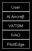
User toggles the display of the user aircraft. In partly active state only the aircraft itself is displayed and in full active state additionally the current altitude as flight level as well as the indicated airspeed and true heading direction separated with a T is displayed.
AI Aircraft toggle the display of AI aircraft generated by flight simulator. In partly active state only the AI aircraft themselves are displayed and in full active state additionally the AI aircraft type, the current altitude as flight level as well as the indicated airspeed and true heading direction separated with a T is displayed.
Note: Please keep in mind that flight simulator only simulates AI aircraft about 70-100 NM around the user aircraft. Therefore no AI aircraft will be displayed on the map outside of this area.
VATSIM toggle the display of pilot and ATC users of the VATSIM (Virtual Air Traffic Simulation) network. In partly active state only the VATSIM users themselves are displayed and in full active state additionally some textual information about the user next to it. Hovering with the mouse cursor over this button will show the time of the last update.
IVAO toggle the display of pilot and ATC users of the IVAO (International Virtual Aviation Organization) network. In partly active state only the IVAO users themselves are displayed and in full active state additionally some textual information about the user next to it. Hovering with the mouse cursor over this button will show the time of the last update.
PilotEdge toggle the display of pilot users of the PilotEdge network. In partly active state only the PilotEdge users themselves are displayed and in full active state additionally some textual information about the user next to it. Hovering with the mouse cursor over this button will show the time of the last update.
Note: VATSIM and IVAO cannot be combined with the button AI Aircraft, but PilotEdge can. For the latter AI Aircraft toggles the display of PilotEdge drone aircraft.
Object Layers
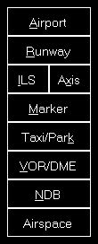
Airport toggles the display of the airport symbols. In partly active state only the airport symbols themselves are displayed and in full active state additionally the airport ICAO code.
Runway toggles the rendering of the runway surfaces. In partly active state only the runway surfaces themselves are displayed and in full active state additionally the runway idents on both sides of the runways.
ILS toggles the rendering of the ILS beams. In partly active state only the ILS beams themselves are displayed and in full active state additionally the ILS idents.
Axis toggles the rendering of the runway axes - a dotted line from the runway start. There is no partly active state available for this layer.
Marker toggles the display of the marker symbols. In partly active state only the marker symbols themselves are displayed and in full active state additionally the marker types (outer marker (OM), middle marker (MM), inner marker (IM), back course marker (BC)).
Taxi/Park toggles the display of the taxiway, apron and park area surfaces. In partly active state only the surfaces themselves are displayed and in full active state additionally the taxi point and parking names.
VOR/DME toggles the display of the VOR/DME symbols. In partly active state only the VOR/DME symbols themselves are displayed and in full active state additionally the VOR/DME idents.
NDB toggles the display of the NDB symbols. In partly active state only the NDB symbols themselves are displayed and in full active state additionally the NDB idents.
Airspace toggles the display of airspace boundaries. In partly active state only the airspace boundaries themselves are displayed and in full active state additionally the airspace names.
Airway and Waypoint Layers

Airway High toggles the display of high (jet) airways together with their connecting waypoints. In partly active state only the airways and waypoints themselves are displayed and in full active state additionally the airway names and waypoint idents.
Airway Low toggles the display of low (victor) airways together with their connecting waypoints. In partly active state only the airways and waypoints themselves are displayed and in full active state additionally the airway names and waypoint idents.
Waypoint toggles the display of all waypoints including waypoints not connected to any airways. In partly active state only the waypoints themselves are displayed and in full active state additionally the waypoint idents.
Other Layers
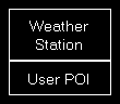
Weather Station toggles the display of weather stations. In partly active state only the weather stations themselves are displayed and in full active state additionally the weather station ICAO codes.
User POI toggles the display of user points of interest (POI). In partly active state only the points of interest themselves are displayed and in full active state additionally the points of interest names.
Background Types
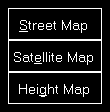
If no background type is selected the map is displayed on a plain surface colored in black.
Street Map switches the map background to a street map.
Height Map switches the map background to a height map which displays the ground level elevation.
Find Object

Find Object shows the Find Object dialog.
Zoom Options
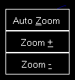
Auto Zoom enables or disables the automatic zoom based on the current aircraft altitude above ground.
Note: The automatic zoom feature can be configured on the Settings module.
Zoom + zooms in and Zoom - zooms out.
Aircraft Options
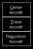
Center Aircraft centers the map on the current aircraft position.
Trace Aircraft enables or disables the drawing of an aircraft trace line.
Repositon Aircraft allows you to quickly reposition the aircraft. After this action is activated the next click on the map will open the reposition aircraft dialog below. To cancel the repositioning action again just click a second time on this button.
Other Options
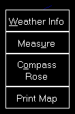
Weather Info toggles the display of a wind arrow in the top center of the map. In partly active state only the wind arrow itself is displayed and in full active state additionally the current wind speed and true direction separated with a T as well as the visibility range and temperature are displayed.
Measure allows you to quickly measure the distance between two points on the map. After this action is activated first click on the start and then on the end point. Now the distance between these two points together with the true heading from the first to the second point is displayed.
Compass Rose toggles the display of a compass rose around the aircraft.
Print Map allows you to print the current map view.
Note: You can define the used printer in the Settings module; same goes for the used color schema used for printing.
Pop-Up Menu
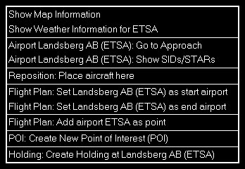
After you right-clicked (long touch) on any point of the map this pop-up menu will open.
Map Information
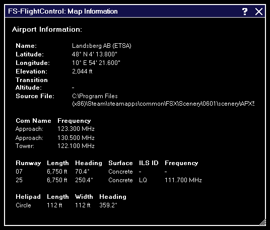
Using the menu item Show Map Information will open this pop-up window showing detailed information about all nearby facilities.
Create New Point of Interest (POI)
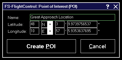
You can create a new point of interest (POI) at any map location.
Just enter a name for it here and if you want you can also change the exact location manually.
Show SIDs and STARs
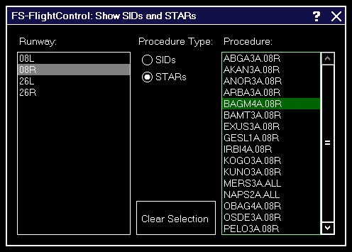
Show any Standard Instrument Departure (SID) or Standard Terminal Arrival Route (STAR) procedure on the map.
Therefore first select the corresponding runway, then the type of the procedure you want to see and finally the procedure itself.
Afterwards the procedure selected is immediately displayed on the map.
To remove the displayed procedure from the map again, use the button Clear Selection.
Footer Information
In the footer of the map some additional information can be displayed.
You can choose what is displayed there in the Settings module.
Cursor Position
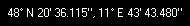
In the bottom left of the map the current mouse cursor position can be displayed.
Frames per Second

In the bottom center of the map the current frames per second can be displayed.
Map Scale

In the bottom right of the map you can always see the current map scale.
Icons Legend
In the following all icons used on the map are explained.
NDB
![]()
This shows a NDB (Non-Directional Beacon).
VOR
![]()
This shows a VOR (VHF Omnidirectional Radio Range).
![]()
And this a VOR that includes a DME (Distance Measuring Equipment).
DME
![]()
This shows a DME only.
TACAN
![]()
This shows a TACAN (Tactical Air Navigation).
Settings
Map Colors
These color settings are related to the Moving Map module.
Colors and Text Settings
In this area you can highly customize the appearance of the map.
We decided to put this into the aircraft related settings. Although this seems not to be aircraft related at first sight, but this enables you to emphasis certain map parts based on the currently loaded aircraft: For example when using a small aircraft you might want to highlight more the small gates and do not care a lot about ILS, but when using a big jet the large gates are much more interesting. Same goes for other parts on the map which might be more interesting for certain aircraft types than others.

All colors and text sizes can be defined per map type.
Therefore please first select the map type.
Colors and Text Sizes for Map Type
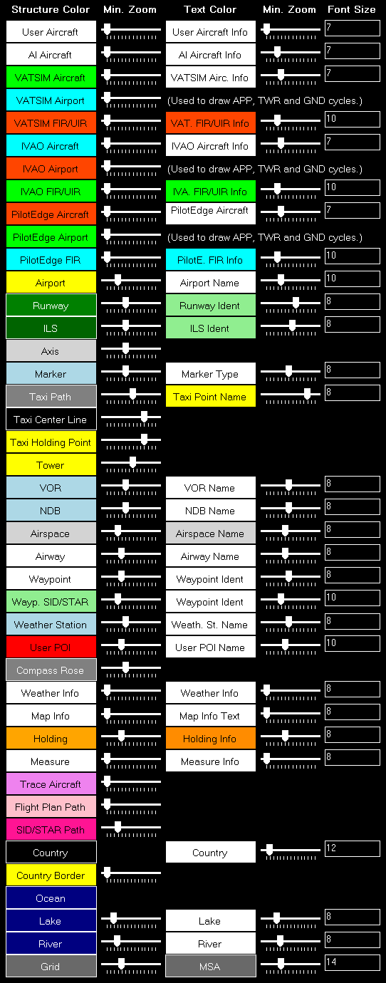
Here all currently defined colors and text sizes are displayed for the selected map type.
The Structure Color is always the color of the item itself, like the runway surface of the runway, whereas Text Color the color of the corresponding text is, like the runway idents of the runway.
The Min. Zoom next to the Structure Color defines the minimum map zoom level needed that this structure (like the runway surface) is shown. Accordingly the second Min. Zoom next to the Text Color defines the minimum map zoom level needed that the corresponding text (like the runway idents) is shown.
Font Size, the last column, enables you to define the size of the displayed text.
Parking
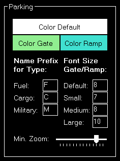
This area lets you define colors and text sizes for the different parking types like gates and ramps depending on their sizes.
Additionally you can define text prefixes to be used for a certain type like fuel, cargo or military.
Tooltip
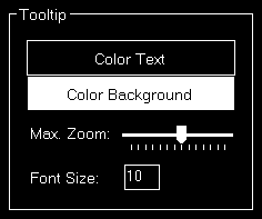
When hovering over certain map elements like an airport a tooltip is displayed shown the full name of the airport.
In this section you can define the appearance of this tooltip as well as the maximum map zoom level until that the tooltip should be displayed.
Map Display
These display settings are related to the Moving Map module.
Auto Zoom
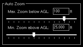
The Moving Map module also features an auto zoom function which will zoom the map in and out according to the current aircraft altitude.
You can configure this feature here by first entering the maximum zoom level (fully zoomed in) that should be reached if the aircraft is below the entered altitude above ground.
Then, for the upper end, you define the minimum zoom level (fully zoomed out) that should be reached above the entered altitude.
Between these two altitudes the zoom will be equally divided automatically.
Aircraft Display
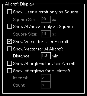
Here you can choose from certain options related to the display of the aircraft on the map.
First you can define if the user and/or AI aircraft are only shown as squares instead of an aircraft image. In this case you can also enter a size for the squares.
Furthermore you can enable or disable a distance vector being displayed in front of each user and/or AI aircraft. In this case you can enter the length of the vector in minutes.
Additionally so called afterglows - dots behind the aircraft - can be enabled or disabled for user and/or AI aircraft. In this case you can enter an interval as well as the number of dots that should be displayed.
Grid and Minimum Sector Altitude (MSA) Display
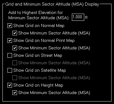
First you can define here the altitude that is added to the highest elevation in each sector when calculating the Minimum Sector Altitude (MSA).
Additionally you can choose when the map grid including the Minimum Sector Altitude (MSA) is displayed in the first place.
Display Options
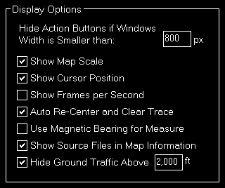
You can define several display options here.
First you can set a window width below that the left and right action buttons are hidden.
Note: This is only used for detached map windows.
Below that you can choose if you want the map scale, cursor position and frames per second displayed on the bottom of the map view or not.
Additionally you can disable the automatic re-center of the map and clear aircraft trace (if enabled) after the aircraft position has been changed from the flight simulator itself (after there was a crash, for example).
Compass Rose
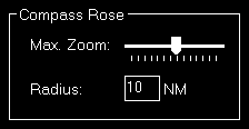
Use these settings to define the maximum zoom level up to the compass rose (when this function is enabled) should be displayed and how wide its radius should be.
Map Other
These settings are related to the Moving Map module.
Refresh Rate

You can define here how often the map view gets updated.
By default that is set to once per second.
Custom Update Rate

If you uncheck the Default Update Rate checkbox you can define the update rate yourself.
The slider then ranges from very low (every 60 visual frames on flight simulator) to very high (every single visual frame).
Note: Please keep in mind that setting the data update rate to very high may lead to performance issues.
Print Options

For map printing you can define here which printer should be used.
Additionally, if you own a commercial license, you can also change the footer text or remove it completely.
Within the footer text you may use the placeholders {date} and {time} to insert the current date and time.
Online Networks
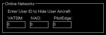
If you enter here your user ID of the available online networks your own user aircraft will not appear additionally as AI aircraft.
Reposition
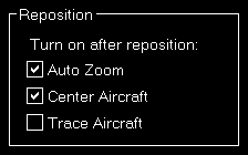
In this section you can define if certain map features are automatically turned on after the map reposition function was used.